


Paragliding Map
Paragliding Map介绍
最全面的网站信息、预报、网络摄像机、照片及更多信息来源!
看看你现在能飞到哪里。全球范围内!
▪ 探索超过14,000个发射点,7,000个降落点,40,000个气象站和39,000个网络摄像机。
▪ 来自DHV、Flyland、FFVL、滑翔伞地球等官方数据。
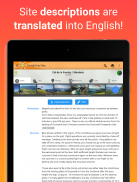
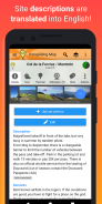
▪ 自动将网站描述翻译成您的语言。
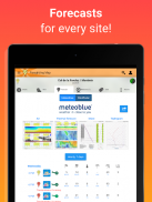
▪ 来自WindFinder的3天天气预报。
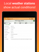
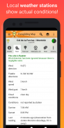
▪ 来自Pioupiou、Holfuy、MADIS和FFVL的实时气象站数据,为您显示实际天气情况。
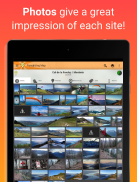
▪ 起飞和降落区域的照片,让您对每个地点都有很好的印象。
▪ 对地图进行筛选,只显示滑翔伞、悬挂滑翔、速度飞行、热力飞行、翱翔、远足与飞行、公共交通、风速等的起飞地点!
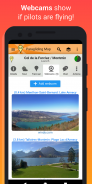
▪ 网络摄像头显示在地图上,并自动显示在发射详情中。
▪ 在地图上查看将来会出现的地图。
▪ 使用导航提供前往每个景点的驾驶方向。
▪ 可保存最喜欢的站点,方便日后访问。
▪ 每个发射点都有聊天群。联系当地飞行员,组织拼车、滑翔伞旅行和接机。
▪ 自由文本搜索站点名称、城市或地区。
▪ 使用Google Earth以3D方式查看飞行地点。
▪ 向朋友发送 "SOS!"和 "我需要搭车 "的消息,包括您的GPS坐标。
▪ 通过Facebook、Twitter、消息和电子邮件轻松分享景点和地图细节。
▪ 链接到原始数据源,让您可以轻松地从DHV、Flyland、FFVL和Paragliding Earth直接获取更多信息。
▪ 包括全面的支持。
我们随时欢迎您的反馈。帮助我们打造出世界上最好的滑翔伞应用程序!
Paragliding Map是移动App版本的ParaglidingMap.com.
隐私政策和条款可以在 http://www.paraglidingmap.com/TermsAndConditions.aspx 中查看
Paragliding Map - 版本11.6.0
(19-11-2024)Paragliding Map - APK信息
APK版本: 11.6.0程序包: com.paraglidingmapParagliding Map的最新版本
其他版本


同类应用
 3.783.84.73-


